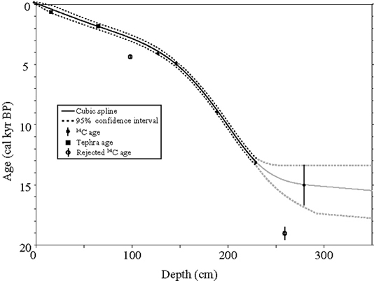
Age-depth model for core GY05. The age model is constrained by 5 radiocarbon ages and 2 tephra ages, and indicates that the core from the central sub-basin contains the entire Holocene history of the lake, and perhaps the entire record beginning immediately after Pleistocene deglaciation. The age model is poorly constrained near the bottom of the core, but should be improved by fall 2007. The cubic spline and confidence intervals were developed following Heegaard et al. (2005). Gray lines indicate poorly constrained age model and associated 95% confidence intervals. Error bars show the 2-sigma ranges for the calibrated 14C ages.

Organic matter content from Greyling and nearby (30 km to the west) Hallet Lakes over the past 5 kyr. The cores from the two lakes are independently dated, so the remarkable similarity in OM, especially over the past 2 kyr, suggests that OM is being influenced by regional climate phenomena. At Hallet Lake, OM is well correlated to Aleutian Low (AL) strength; given the similarity between the two records, OM at both Hallet and Greyling Lakes may have recorded low frequency variability in the Aleutian Low over the past several thousand years.
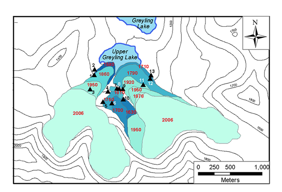
Glacier extents over the past 500 years in Greyling valley, red numbers = yr AD. Evidence for ice extents based on: 2006 = field mapping; 1978 = 1:63,360-scale aerial photographs; 1950 = USGS topographic maps; all others = glacial evidence and lichenometric ages. Lichen stations indicated by black triangles (Table 3). Contour intervals in cm asl.
The LIA moraine sequence records a complex history of advance and retreat from the multiple cirques: the west tongue of the eastern glacier experienced limited advance compared with the other glaciers in the valley, but was the only glacier to preserve a record of several moraines deposited progressively down-valley during the LIA Lichenometric ages suggest the glacier underwent several episodes of advances and standstills from 16301850 AD, when it reached its full extent, coalescing with the glacier emanating from the east near Upper Greyling Lake . The moraine record suggests that the east tongue of the eastern glacier and the other glaciers in the valley reached their LIA maximum extents earlier, between 1590 and 1730 AD. Recessional moraines record the pauses during the retreat of these larger glaciers, and suggest that most of the recession from the LIA maximum extents occurred during the past 100 yr.
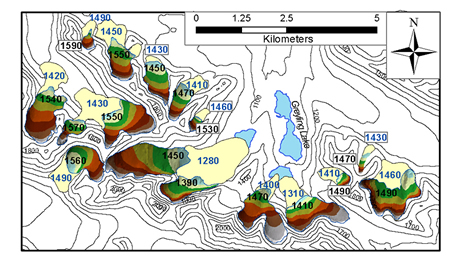
Map of modern (1978) and Little Ice Age glacier extents near Greyling Lake. Modern glacier extents shown with colored elevation bands, LIA extent in tan. Blue numbers are calculated LIA equilibrium line altitude (ELA), black numbers are calculated modern ELA (m asl). Countour interval = 100 m.
ELAs can be sensitive indicators of climate, and the amount of change between the LIA and modern glaciers is indicative of how climate was different during the LIA. For more discussion of what the ELAs near Greyling and Hallet Lakes suggest about climate, read the discussion here.