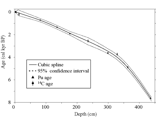
Age-depth model for core GY05. The age model is constrained by 9 radiocarbon ages and 1 plutonium age, and indicates that the core records about 8000 years of the lakes history. The cubic spline and confidence intervals were developed following Heegaard et al. (2005). Error bars show the 2-sigma ranges for the calibrated 14C ages.
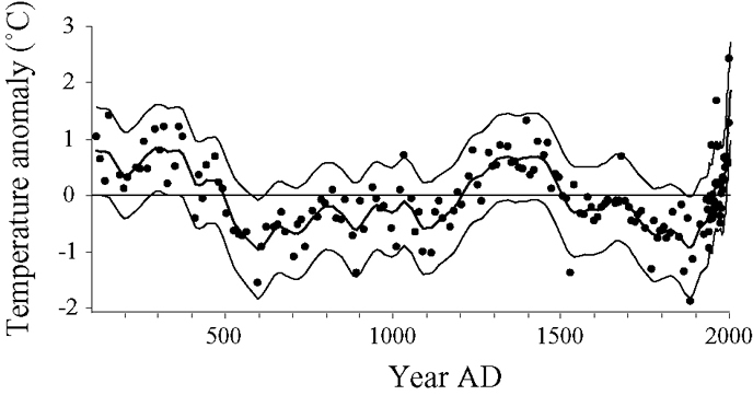
Reconstructed summer temperatures anomalies from the 2 ka average, inferred from BSi concentration from Hallet Lake sediment. Black line indicates the average for the past 2 ka (4.2°C). Thick curve is the 50-year Gaussian-weighted low-pass filtered curve. Thin curves are confidence intervals determined as the RMSEP (boot) values calculated for each point in the reconstruction.
Over the past 80 years, BSi correlates strongly with Valdez summer (JJA) temperature (r = 0.87), and a transfer function was developed using this relation to quantitatively reconstruct summer temperatures for the past 2 kyr. The reconstructed temperatures indicate periods of warm summer temperatures from 100-500 AD, 1300-1500 AD, and after ~1900 AD; predominantly cool periods occurred from 500-1200 AD, and from 1600-1900 AD. Following the maximum LIA cooling, summer temperature warmed rapidly, increasing by 3°C at a pace more than four times faster than the previous warming of the same magnitude from 700-1300 AD. Average summer temperature during the period from 1976-2005 (i.e., current climate regime) is nearly 2°C warmer than the average over the past 2 ka, and the past 20 years are unprecedented in the last 2 ka. The temperature record is largely consistent with other regional and hemispheric proxy records.

Organic matter content from Hallet and nearby (30 km to the west) Greyling Lakes over the past 5 kyr. The cores from the two lakes are independently dated, so the remarkable similarity in OM, especially over the past 2 kyr, suggests that OM is being influenced by regional climate phenomena. At Hallet Lake, OM is well correlated to Aleutian Low (AL) strength; OM at both Hallet and Greyling Lakes may have recorded low frequency variability in the Aleutian Low over the past several thousand years.
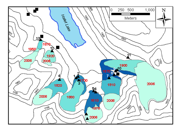
Glacier extents over the past 500 years in Greyling valley, red numbers = yr AD. Evidence for ice extents based on: 2006 = field mapping; 1978 = 1:63,360-scale aerial photographs; 1950 = USGS topographic maps; all others = glacial evidence and lichenometric ages. Lichen stations indicated by black triangles. Contour intervals in cm asl.
With the exception of one station located high on the largest lateral moraine of the easternmost glacier, the lichenometric ages indicate that all of the prominent, bouldery moraines in the southern end of the valley stabilized after ~1500 AD, suggesting that the moraines formed during the LIA. Moraines deposited by glaciers on the west side of the valley suggest a limited LIA advance, and lichen ages (1870-1920 AD) indicate that the moraines stabilized more recently. Also, in contrast to the moraine sequence in the southern part of the valley, older moraines are preserved beyond the LIA extent in these cirques (black squares).
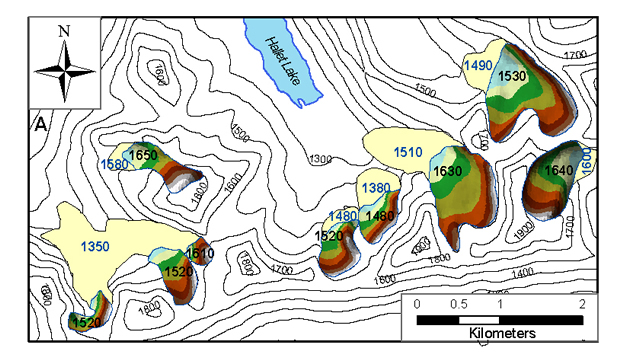
Map of modern (1978) and Little Ice Age glacier extents near Hallet Lake. Modern glacier extents shown with colored elevation bands, LIA extent in tan. Blue numbers are calculated LIA equilibrium line altitude (ELA), black numbers are calculated modern ELA (m asl). Countour interval = 100 m.
Temperature records from Greyling Lake and Valdez during 2005-2006 were used to derive an environmental lapse rate of -7°C km-1 for the area. In this study, glacier geometry was used to estimate (using the AAR method) ELAs based on the 1978 glacier extents. Consequently, the calculated ELAs are controlled by the integrated effects of climate over the few decades prior to the 1978 aerial photographs. The period from 1950-1978 AD was on average 1.5°C warmer than during the maximum LIA cooling (inferred from BSi). This, combined with the environmental lapse rate, suggests that ELA should have lowered by ~210 m. The maximum ELA lowering calculated using the maximum LIA extents for the glaciers near both Hallet and Greyling Lakes is 83 m. This ? ELA is a realistic maximum estimate, and is substantially lower than the expected 210 m. This strongly suggests that the ELA lowering and the LIA glacier advances in the region were limited because of reduced winter precipitation, consistent with a weakened AL inferred from the low OM during the LIA.